Stuck in Croatia?

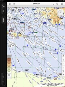
A little background in flight planning for our non pilot friends. The weather is the main factor her and wind (mostly determining our speed over ground) and the the different types of clouds are most important. For planning our route, we have gotten to like a chart called “GRAMET” which is a prognosis based on a computer weather model (GFS) and giving an aeronautical weather forecast for a specific route.

The above example shows the GRAMET for our planned trip from Dubrovnik (LDDU) to Heubach (EDTH). As Heubach isn’t really of international relevance and does not have a weather station of its own, we selected Stuttgart (EDDS) as our destination — just around the corner.

On the picture you see the profile of the surface, showing that our journey starts at sea elevation (0 feet), leads us over the Alpa and later the Swabian Jura. The highest elevation is somewhere in the Alps at roughly 10,000 feet (3,300 meters).

The red dotted line represents the 0°C border. You can see how it moves lower as we get further north. Also you can see the different layers of clouds and their types. On the left you see a few towering cumuli, those are clouds of large vertical extent one tries to avoid due to strong up and down drafts — meaning turbulence. Also there is precipitation forecast in Dubrovnik. The green areas with the strange read symbol mean that there is danger of icing meaning there are water droplets with less than 0°C waiting for a Cessna to come so they can instantly freeze and stick to the leading edges. Not the best thing for us as we don’t have deicing equipment like airliners, meaning we cannot get rid of the ice and therefore get heavier and less aerodynamic and at some point would no longer be able to hold our altitude.

You can also see that for some areas we would expect clouds from the surface up to flight level 200. In principle, clouds are no problem but flying inside clouds for hours isn’t very entertaining and with one engine there is always the theoretical danger of a failure and being able to see the surface and finding an emergency landing spot is a great advantage.

All in all not the optimal weather. We should be able to take off avoiding the towering cumuli but with the Alps inside clouds a technical problem would turn into a huge problem. In addition to that icing on the north side of the Alps where at some point we’d have to descend for landing.

So we have to look at different route alternatives (for example going further west via Italy where the weather should be better), hope for a positive surprise or stay grounded tomorrow. The latter option isn’t the worst one considering the fantastic spa of our hotel (besides the fact that I’d have to visit it together with Achim).

El Gouna to Marsa Alam at 8 knots

When two pros like Markus and Achim are in town, it doesn’t take long for difficult jobs to emerge. Yesterday it was about bringing Ocean Diva II, a 74 foot catamaran, from its previous harbor El Gouna to Port Ghalib (Marsa Alam), 120 nautical miles south.

Due to the revolution and the subsequent decline in tourism, OD II (as friends like to call her) spent some time alone in the harbor and therefore the trip was also a sea trial. 30 knots of tailwind and arrival at an unknown marina in the middle of the night promised an interesting trip.

Another goal was to try out Achim’s newly acquired trolling equipment. The latter was fully achieved: after about 15 minutes a 10kg thuna, two monster fish that first bent the rod and then went off with an aching jaw and last but not least a marvellous 20 kg dorade. Both were expertly cut by Khaled and served as the traditional welcome gift for the harbor employees. Achim — economist by profession — immediately determined the return on investment for his fishing gear (4 more fish) and we are currently working on our business plan as fishermen in Egypt.

This trip was not for sissys (which is why Markus didn’t fully enjoy it) and there were a few challenges that made it more interesting:

  • The crew had to improvise on several occasions, this was clearly not an everyday’s cruise
  • Sea maps and especially harbor entrance maps were considered as non necessary payload
  • The main sail couldn’t be hoisted due to incorrect reefing and correcting the problem at 30 knots of wind and 3.5m waves was deemed too risky
  • The starboard engine broke down due to a problem with the propellor shaft bearing (not the first time, bad workmanship by Volvo)
  • Continuing the trip on one engine and only the jib was slow and impossible with the fuel reserves we had
  • It was then decided to hoist the main sail which did not complete without putting the ship and crew at risk
  • The marina entry at Port Ghalib (no maps!) was quite interesting due to broken and invisible marker beacons. Markus was constantly mumbling something about life vests and dying.

All in all a successful trip. Today we are heading back to El Gouna in a car.

Electronic gadgets

Our trip requires some special equipment. On top of the survival equipment (life vests, life raft, signal flares, first-aid kit, etc.) we have to carry some technical equipment helping us with in air navigation/communication and properly documenting this adventure. In the best case, the documentation will let us keep the memories of this trip alive, in worst case it will be useful information for the aviation accident investigation authorities.

The following equipment will be carried on board:

The primary tools for planning and performing the flight are two Apple iPads. Those devices are a perfect fit for the cockpit and are being relied upon by commercial airlines. We use them to get up to date weather information and warnings from the flight deck but also do the complete navigation with digital maps in PDF format. One iPad replaces a whole cupboard of paper documents and in case of emergency provides for a much quicker lookup of important documents than with the impractical large paper charts and binders. Also stored on the iPads are the checklists and operating instructions for emergencies (e.g. engine failure, landing gear trouble, cabin fire). We will carry two devices with identical data so that we have a backup in case an iPad packs up. Also this allows for parallel use of data: one pilot uses the map to navigate and the other checks the approach plate for the required radio frequencies (when both are playing with their iPads, George the autopilot will have to do the actual flying).

SPOT Connect is a GPS tracker with satellite communication, constantly radiating our position to the satellites (which in turn feed the live tracking page of this blog). In case of emergency, our SPOT can alert the rescue crew or send text messages of up to 45 characters to mobiles and email addresses of predefined recipients. On top of that, it can post to Twitter and Facebook and is therefore capable of everything the modern person couldn't do without for more than 30 minutes a day.


The Thuraya satellite phone allows for making phone calls in areas without mobile phone reception (e.g. in the air), send SMS and even emails. The charges when using it our outrageous so sorry mum, we're not going to call you to discuss the neighbor's cat. The Thuraya phone also acts as a wifi hotspot which lets us access the internet from our iPads in filght. This cannot be compared to your high speed flatrate at but but gives us the opportunity to send important messages, query current weather information and even make posts to this blog. It is all pretty new so there is no experience and at this point we do not know how well Thuraya will work in the cockpit.


The GoPro video cameras that we are going to carry are very robust and waterproof outdoor cameras delivering fantastic wide angle recordings. They will be an important tool to document our adventure. One camera will go inside the cockpit and the other will be mounted outside on the aircraft’s hull. The GoPro app on the iPad and mobile phone provides a convenient feature to remote control the cameras so we can turn them on and off as required.

For still images, we also carry a Canon EOS SLR camera with an all round lens. Last but not least, two laptop computers are part of our equipment so that we have a good platform to post to this blog and prepare our next legs.


Flight planning

AirwaysWhile the little excursion around the home aerodrome only requires a quick look at the map and the weather report, planning our adventure is a tad more complex: during our flight to Egypt we will be crossing several borders and there thus required to file a “flight plan”. This plan contains the exact route, time, details on the aircraft and crew and a few additional things and has to be submitted with the authorities before takeoff. This is not an issue as flight plans can also be used for domestic flights and every pilot should be familiar with them. Customs clearance which has to be requested upfront (we are going to leave the EU and Schengen) is a no brainer and free of charge.

Several other factors make it more complex: while Germany is a private pilot’s paradise with excellent maps, a large number of public airfields, a reliable weather service and excellent air traffic control, things are rather different south of the Alps. In Greece, flying according to visual flight rules (VFR, the most common way of flying for private pilots) is possible but there are no official maps. One has to be creative. In Egypt, self controlled VFR isn’t possible at all, only controlled VFR (CVFR) and instrument flight (IFR) as used by airliners. IFR allows penetrating clouds and therefore reaching the destination when the weather is less than great but one is bound by the instructions of air traffic control (ATC) who will issue course and altitudes and any deviations like circling overhead your friend’s house and greeting are not possible (our route will lead us directly overhead the Pyramids of Cairo so it’s a pity).

We will be flying “IFR”, i.e. under Instrument Flight Rules but still have to be prepared for safety (weather) or emergency (technical problem) landings at any other aerodrome on the way. This requires maps for both visual and instrument flying and landing charts for all airports that are close to our route. All this information has to be up to date. Luckily we didn’t plan this trip 5 years ago as we would have had to reserve half of our useable load for the paper binders with the maps. Not just impractical for logistics but also an issue when a chart is needed due to a diversion and there is limited time to go through books and find the right paper. Today one can fly truly paperless. The GPS devices come with a “moving map” and on two iPads, we will be carrying all required checklists, landing charts, IFR and VFR maps. As we have two devices, there is sufficient redundancy.

We’ve already determined our preferred routing. It will lead us from our home base Heubach (near Stuttgart) in southeasterly direction to the Alps, Austria, Slovenia, Croatia, Albania, Greece and the open sea to Egypt. Due to the aircraft’s endurance, customs (we’re not just leaving the EU but also Schengen) and cost (aircraft fuel is extremely expensive in Egypt and we want to buy as little as possible there) we need several stopovers. The first one in Dubrovnik (Croatia), the second in Sitia (on Crete in Greece), the third in Port Said (Egypt) as the port of entry and then onward to our destination El Gouna at the Red Sea.

We’ve prepared all maps, opening hours, fuel prices for this route and taken a first look at the landing procedures. Next we will have to come up with a list of alternate airports in case we have to divert, due to bad weather, revolution in Port Said, strikes in Greece, a technical problem, etc.