The worst case has happened

The worst case that everybody feared has happened: we are stuck in Croatia. Markus determined that the weather is a no go and is looking forward to the excellent weather forecast for Monday. In reality, the weather is definitely doable without taking risk.

An important role in this decision played the fantastic spa of the hotel and the view from our hotel room. Achim is now forced to look at Markus’s wobbly body for a whole day and find a way to get the work schedule for Monday done on a Sunday in a hotel room.

Stuck in Croatia?

A little background in flight planning for our non pilot friends. The weather is the main factor her and wind (mostly determining our speed over ground) and the the different types of clouds are most important. For planning our route, we have gotten to like a chart called “GRAMET” which is a prognosis based on a computer weather model (GFS) and giving an aeronautical weather forecast for a specific route.

The above example shows the GRAMET for our planned trip from Dubrovnik (LDDU) to Heubach (EDTH). As Heubach isn’t really of international relevance and does not have a weather station of its own, we selected Stuttgart (EDDS) as our destination — just around the corner.

On the picture you see the profile of the surface, showing that our journey starts at sea elevation (0 feet), leads us over the Alpa and later the Swabian Jura. The highest elevation is somewhere in the Alps at roughly 10,000 feet (3,300 meters).

The red dotted line represents the 0°C border. You can see how it moves lower as we get further north. Also you can see the different layers of clouds and their types. On the left you see a few towering cumuli, those are clouds of large vertical extent one tries to avoid due to strong up and down drafts — meaning turbulence. Also there is precipitation forecast in Dubrovnik. The green areas with the strange read symbol mean that there is danger of icing meaning there are water droplets with less than 0°C waiting for a Cessna to come so they can instantly freeze and stick to the leading edges. Not the best thing for us as we don’t have deicing equipment like airliners, meaning we cannot get rid of the ice and therefore get heavier and less aerodynamic and at some point would no longer be able to hold our altitude.

You can also see that for some areas we would expect clouds from the surface up to flight level 200. In principle, clouds are no problem but flying inside clouds for hours isn’t very entertaining and with one engine there is always the theoretical danger of a failure and being able to see the surface and finding an emergency landing spot is a great advantage.

All in all not the optimal weather. We should be able to take off avoiding the towering cumuli but with the Alps inside clouds a technical problem would turn into a huge problem. In addition to that icing on the north side of the Alps where at some point we’d have to descend for landing.

So we have to look at different route alternatives (for example going further west via Italy where the weather should be better), hope for a positive surprise or stay grounded tomorrow. The latter option isn’t the worst one considering the fantastic spa of our hotel (besides the fact that I’d have to visit it together with Achim).

No flight today

After reaching our final destination El Gouna yesterday after 13 hours of flight, we will stay on the ground today — or let's better say on the water. Enjoying the Egyptian temperatures while swimming, snorkeling, fishing, wakeboarding and relaxing. Our next take off heading north again is planned for mid next week and we will of course report here again.

A big thank you to Ahmed and G.A.S.E

It is time for a big thank you to Ahmed and General Aviation Support Egypt (G.A.S.E) with Eddie for the incredible service we received and without which this trip would not have been possible. Being able to fly to Egypt in a private airplane shouldn't be taken for granted and requires a lot of effort and time to fight the bureaucracy. On our own, we would have never managed to get the required paperwork done and in addition to doing a superb job in securing our permissions and moving every problem out of the way, Ahmed even got us all fees waived in Port Said. We can therefore wholeheartedly recommend Ahmed and Eddie and their small venture to all pilots and are definitely going to rely on them again in the future. GA in Egypt has a bright future thanks to G.A.S.E.!

Day 2 preparation

Getting ready for our second leg from Dubrovnik to Sitia in Greece. Weather doesn't look that great today but we will give it a try.

Filled up our jelly cans here yesterday after arrival as getting AVGAS will become challenging from now on.

Had a great dinner in the old city center of Dubrovnik yesterday. A georgeous city we can recommend visiting. We are already looking forward to our trip back and the stopover in Dubrovnik.

20130215-072722.jpg

Weather — go or no go?

We've already talked a bit about it — the weather is what pilots fear more than anything else. We are allowed to fly through clouds (IFR, instrument flying) but there are limits to this, as below 0°C ice forms on our aircraft which can quickly become a major problem. We can fly below, above, beside and through the clouds, provided they don't cause icing. Before taking off, we would like to know the odds of reaching our destination as planned. It would be unfortunate if we came to realize en route that we have to turn around due to icing or make a major detour. In general, we will only take off if we know that we can land safely, i.e. there are a few inches of clear air between the cloud base and the landing strip. Our certification only requires us to have 400 meters of visibility and 200 feet (60m) between the clouds and and the runway but we don't want to get even close to such conditions — this is only for pilots that fly frequently and are well trained in such conditions.

There are regular weather reports for pilots, those report actual conditions at the weather stations and therefore are very reliable. Larger aerodrome have a system which every 30 minutes determines visibility, cloud coverage, temperature, dew point, pressure, etc. The weather of the future is an entirely different animal. Meteorologists (similar to fortune tellers) specialize in asking their crystal balls (read: expensive computer models) for aviation weather which not only covers the surface weather but also conditions at higher altitudes. Everybody knows that predictions are hard, especially about the future. Some weather conditions are easy and reliable to predict, others almost impossible. Fog formation is an example of a weather phenomenon that until today, meteorologists don't grasp as it depends a lot on local conditions which are not accurately represented in the computer models. Our start aerodrome is ideally situated and only very rarely a victim of fog. Another aerodrome just a few miles away is basically covered in fog throughout the winter.

A private pilot knows a few basic things about weather. There are lows and highs. In low pressure areas, air ascends, condensates and forms clouds with rain or snow. In high pressure areas, air descends, stabilizes and we get clear skies. High is good, low is bad (incidentally, that's also Markus's attitude towards life). Even worse are fronts, those are the boundaries of air masses with different characteristics. There are cold and warm fronts. Especially cold fronts are evil as they produce thunderstorms, strong rain and reach up very high with severe icing. We definitely don't want to fly through a cold front, that's for cowboys. In the above map from the French Met Office (yes, smart pilots collect data from all over the world because instead of having one decent European Met Office, we have a zillion of mediocre national weather services doing exactly the same thing) we see the weather from today 16:00 UTC (Greenwich Mean Time or Universal Coordinate Time, used by pilots all around the world). Over Croatia, there is a cold front (blue line with teeth), moving east with 15 knots and northwest of it a small warm front (red with semi circles), moving to Italy. In the area of the cold front we expect thunderstorms, let's check this with the current lightning chart (sferics) shown above.

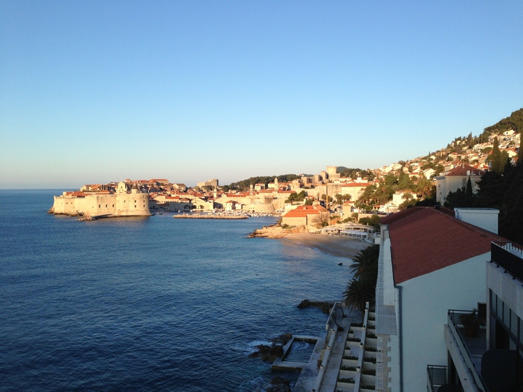
Indeed, there are thunderstorms (the yellow and red dots) and this is a no-go zone for us. However, the front is moving and by tomorrow it will be a Greek problem (don't they have enough already?). Let's have a look at the forecast for our destination aerodrome Dubrovnik, the Terminal Aerea Forecast (TAF):

LDDU 131125Z 1312/1412 12017KT 9999 BKN040 TX10/1412Z TN04/1405Z TEMPO 1312/1321 RA BECMG 1322/1324 04015KT BECMG 1409/1411 18007KT

A bit cryptic but in order to be able to read that, pilots attend ground school. We can see that today (Feb 13) between 12:00 UTC and 21:00 UTC there is supposed to be rain (RA). Yes, that fits to what we've seen earlier. The rain is going to stop at 22:00 and only a feeble wind (7 knots) coming from south (180°) will remain. Everything that could be bad for us like thunderstorms, rain, snow, storms would be listed here.

Now let's look at the TAF of our start aerodrome Heubach (EDTH). Unfortunately Heubach does not provide its own weather but we have the large airport of Stuttgart (EDDS) just around the corner and can use its forecast:

EDDS 131100Z 1312/1412 VRB03KT 9999 SCT040 PROB40 TEMPO 1312/1321 4000 -SN BR BKN014

Also looking good. Very little wind (3 knots) from variable directions (VRB), good visibility, scattered clouds 4000 feet above the airfield, a little bit of snow with 40% probability and some fog between 12:00 UTC and 22:00 UTC combined with low clouds. After that until the end of the forecast period on Feb 14 at 13:00 UTC only good weather. Fantastic.

So it's looking good in A (Stuttgart) and in B (Dubrovnik), but what about the weather between A and B, that's a full 1000km? Here, we resort to a larger scale forecast model based on the Global Forecasting System (GFS), the weather model of the USA which, in contrast to the semi-capable European systems, is freely accessible (in the USA, all data produced with tax money is generally freely available, something the Europeans should take a closer look at). Here a very nice rendering of our flight profile from GFS for the planned time of flight.

This is really good. The yellow line is us at flight level 150 (15 000 feet, ca. 5km). Below you see the topography with the Alps and Dubrovnik at sea level. The dashed red line is the zero degree line which is currently at the surface in Germany and 5000 feet in Dubrovnik. In the middle you can see areas with a green shading meaning moderate icing (which in reality is quite serious with our little plane), however well below our planned altitude. There you also find clouds but they are broken, i.e. we will find our way around them. The temperature at the planned altitude is forecast between -19°C and -22°C so we hope our heater will work and we won't regret boarding the aircraft in our Egyptian beach wear.

Another interesting image is the infrared satellite photo. Using a color scale it shows the temperature of the cloud tops. Given that we have temperature data for many places on the surface and a rough idea about how air cools with altitude (the standard model assumes 2°C per 1000 feet), we can roughly estimate the top of the clouds and know which clouds we will be able fly over, fly through or (as we prefer) circumnavigate. This is a current picture, by tomorrow the nasty stuff will be gone because it's directly related to the high reaching cold front.

In summary: gorgeous weather. Markus can return his $19 Easyjet ticket that he purchased earlier. Oh, there are no refunds with Easyjet!

Airplane batteries

With the Boeing 787 Dreamliner and its exploding lithium batteries in the news, everybody is now aware of how important batteries are in aircraft. The Cessna is no exception but it relies on conventional lead acid batteries, just like cars. However, aircraft batteries are of higher quality and most importantly higher price. About 400-500 € for one battery so every aircraft owner wants to know when is the right time to swap batteries. The manufacturer's manual is of no help here as he's only interested in selling batteries and the mechanic also makes money in the whole process. However, one doesn't want to stretch it too far and risk getting stuck in a remote place with an aircraft that won't start. Lead acid batteries have the mean trait of suddenly breaking down when the internal chemistry goes belly up.

In principle, it is possible to hand prop an aircraft by turning the propellor. In the good old times airplanes were started like this. A few years ago, I went with Markus and his girlfriend (now: fiancée) to the beautiful Lake of Constance with a broken starter in a Cessna 172 and hand propping was the only option to make it back home. Quite expectedly, Markus immediately shitted his pants and protested that this was too dangerous, not allowed, we should leave the aircraft there, he will not participate in this, etc. In the back of the airplane sat his girlfriend who at this time was pondering whether this guy could be a worthy husband one day. I eventually prevailed and in the meantime a whole crowd of spectators had formed. An expert for oldtimer aircraft had instructed me just a few days earlier and explained the technique to increase the odds of keeping one's fingers and arms (a very interesting video by the FAA and for medical students this anamnesis). Markus sat in the safe cockpit and operated the ignition and power lever. After a few attempts, the engine started and Mirna realized the stark contrast between Markus and a real man. It took over 2 years for her to recover from this event and announce the engagement.

After this little digression (and the usual appreciation of Markus's strengths), back to our Cessna. When test flying it a week ago in the cold winter after a few weeks of not having flown her (but always connected to a trickle charger) I got the impression that the battery was a little weak. The engine did eventually start but it surely took some convincing. The battery is already 7 years old and most owners swap it after 5 years at the latest. Being a Swabian (we despise the Scots for being wasteful) I don't just dispose perfectly workable batteries but I also wouldn't want to end up without a working battery as the 540 cubic inch (9 liter) 6-cylinder is a bit difficult to hand prop. So I need to determine how strong the battery still is. The manufacturer offers guidance and special test equipment which causes a predefined load and after one hour measures the remaining voltage. A tester costs between $1000-$2000 — that's aviation! For my battery the load according to the manual is 200 watts and after one hour the voltage is supposed to be 20 volts. If less than 80% (i.e. 16V), the battery is to be swapped. Off we go to Home Depot to get 4 12V halogen bulbs, car battery clamps and some wire. Twice 2 bulbs in parallel and both units daisy chained and ready is the 24V/200W battery tester which set me back by 4.50 €.

The test has to be conducted at 20°C ambient temperature, therefore I had to remove the battery from the aircraft and take it back home. 200W is quite a lot so I put the apparatus on the balcony (perfect 0°C there) and left the battery in the apartment. I started at 25.2V and after one hour measured exactly 15V. After all I was right in my suspicion, this battery is finished! Luckily I had a new battery on the shelf and plenty of sulfuric acid to activate it (I normally use it to spray on the faces of random people in the subway). Now Markus will of course claim that I could have skipped all that rubbish and just replaced the battery after 5 years like everyone else. Well, as always he's talking about other people's money and I got a full 7 years out of this battery and thus saved 114 €. What was the company slogan of my former employer IBM: We have to save money — at any cost!

Miles High Music Club

Friends of Markus know very well that he wouldn't go anywhere without his favorite music performed by Engelbert Humperdinck. The airplane cockpit is no exception to that rule. Therefore I have undertaken the task of coming up with a technical solution to Markus' musical needs. Of course there's something in it for me, too: when you're listening to music, you can't make your copilot's ear bleed and I can focus on more pleasant conversations (with air traffic control) and just relax and enjoy the view.

All modern planes have a so called "audio panel", a sort of mixer. In smaller aircraft with poor sound insulation (well, you're really damn close to the engine), everbody usually wears a headset and the modern ones even come with active noise cancelling. The headsets are connected to the audio panel which provides a plethora of options.

You can set it up to have all people on board communicate with each other, separate the passengers from the pilots, make passenger announcements from the cockpit to the passengers (yes, just like in a big airplane!), select different radios (even separate ones for each pilot tuned to different frequencies) and last but not least isolate the pilots from each other — a feature surely designed with Markus in mind. When having my audio panel installed, I had them put in a connector for an external music planer. The audio panel is very smart in that it will playback the music but automatically mute it when a radio call comes in or the pilot pushes his microphone button. Nobody has to be afraid to miss important radio calls when rocking one's socks off above the clouds.

The audio connector is a cable with a headphone plug (just like an iPod earphone) but that's really oldfashioned and not something I would dare to offer to Markus. Imagine the iPhone connected with a long cable which gets in the way and leaves the pilot bonded. A recently released audio panel includes a Bluetooth receiver for wireless music and that feature only costs 1000 € extra.

Luckily there is a chaper option, more precisely a 16,56 € option. This little Bluetooth receiver box with an integrated rechargeable battery gets hooked up to the earphone plug and stowed away with the cable in the side pocket. Now the mobile phone needs to etablish a Bluetooth connection and Engelbert starts singing for Markus. This works so well that I just ordered another box for my car. When I complained with my BMW dealer that my car wouldn't allow me to use Bluetooth for music, he recommended purchasing the 2012 model. I was not convinced.

Electronic gadgets

Our trip requires some special equipment. On top of the survival equipment (life vests, life raft, signal flares, first-aid kit, etc.) we have to carry some technical equipment helping us with in air navigation/communication and properly documenting this adventure. In the best case, the documentation will let us keep the memories of this trip alive, in worst case it will be useful information for the aviation accident investigation authorities.

The following equipment will be carried on board:

The primary tools for planning and performing the flight are two Apple iPads. Those devices are a perfect fit for the cockpit and are being relied upon by commercial airlines. We use them to get up to date weather information and warnings from the flight deck but also do the complete navigation with digital maps in PDF format. One iPad replaces a whole cupboard of paper documents and in case of emergency provides for a much quicker lookup of important documents than with the impractical large paper charts and binders. Also stored on the iPads are the checklists and operating instructions for emergencies (e.g. engine failure, landing gear trouble, cabin fire). We will carry two devices with identical data so that we have a backup in case an iPad packs up. Also this allows for parallel use of data: one pilot uses the map to navigate and the other checks the approach plate for the required radio frequencies (when both are playing with their iPads, George the autopilot will have to do the actual flying).

SPOT Connect is a GPS tracker with satellite communication, constantly radiating our position to the satellites (which in turn feed the live tracking page of this blog). In case of emergency, our SPOT can alert the rescue crew or send text messages of up to 45 characters to mobiles and email addresses of predefined recipients. On top of that, it can post to Twitter and Facebook and is therefore capable of everything the modern person couldn't do without for more than 30 minutes a day.


The Thuraya satellite phone allows for making phone calls in areas without mobile phone reception (e.g. in the air), send SMS and even emails. The charges when using it our outrageous so sorry mum, we're not going to call you to discuss the neighbor's cat. The Thuraya phone also acts as a wifi hotspot which lets us access the internet from our iPads in filght. This cannot be compared to your high speed flatrate at but but gives us the opportunity to send important messages, query current weather information and even make posts to this blog. It is all pretty new so there is no experience and at this point we do not know how well Thuraya will work in the cockpit.


The GoPro video cameras that we are going to carry are very robust and waterproof outdoor cameras delivering fantastic wide angle recordings. They will be an important tool to document our adventure. One camera will go inside the cockpit and the other will be mounted outside on the aircraft’s hull. The GoPro app on the iPad and mobile phone provides a convenient feature to remote control the cameras so we can turn them on and off as required.

For still images, we also carry a Canon EOS SLR camera with an all round lens. Last but not least, two laptop computers are part of our equipment so that we have a good platform to post to this blog and prepare our next legs.


Flight planning

AirwaysWhile the little excursion around the home aerodrome only requires a quick look at the map and the weather report, planning our adventure is a tad more complex: during our flight to Egypt we will be crossing several borders and there thus required to file a “flight plan”. This plan contains the exact route, time, details on the aircraft and crew and a few additional things and has to be submitted with the authorities before takeoff. This is not an issue as flight plans can also be used for domestic flights and every pilot should be familiar with them. Customs clearance which has to be requested upfront (we are going to leave the EU and Schengen) is a no brainer and free of charge.

Several other factors make it more complex: while Germany is a private pilot’s paradise with excellent maps, a large number of public airfields, a reliable weather service and excellent air traffic control, things are rather different south of the Alps. In Greece, flying according to visual flight rules (VFR, the most common way of flying for private pilots) is possible but there are no official maps. One has to be creative. In Egypt, self controlled VFR isn’t possible at all, only controlled VFR (CVFR) and instrument flight (IFR) as used by airliners. IFR allows penetrating clouds and therefore reaching the destination when the weather is less than great but one is bound by the instructions of air traffic control (ATC) who will issue course and altitudes and any deviations like circling overhead your friend’s house and greeting are not possible (our route will lead us directly overhead the Pyramids of Cairo so it’s a pity).

We will be flying “IFR”, i.e. under Instrument Flight Rules but still have to be prepared for safety (weather) or emergency (technical problem) landings at any other aerodrome on the way. This requires maps for both visual and instrument flying and landing charts for all airports that are close to our route. All this information has to be up to date. Luckily we didn’t plan this trip 5 years ago as we would have had to reserve half of our useable load for the paper binders with the maps. Not just impractical for logistics but also an issue when a chart is needed due to a diversion and there is limited time to go through books and find the right paper. Today one can fly truly paperless. The GPS devices come with a “moving map” and on two iPads, we will be carrying all required checklists, landing charts, IFR and VFR maps. As we have two devices, there is sufficient redundancy.

We’ve already determined our preferred routing. It will lead us from our home base Heubach (near Stuttgart) in southeasterly direction to the Alps, Austria, Slovenia, Croatia, Albania, Greece and the open sea to Egypt. Due to the aircraft’s endurance, customs (we’re not just leaving the EU but also Schengen) and cost (aircraft fuel is extremely expensive in Egypt and we want to buy as little as possible there) we need several stopovers. The first one in Dubrovnik (Croatia), the second in Sitia (on Crete in Greece), the third in Port Said (Egypt) as the port of entry and then onward to our destination El Gouna at the Red Sea.

We’ve prepared all maps, opening hours, fuel prices for this route and taken a first look at the landing procedures. Next we will have to come up with a list of alternate airports in case we have to divert, due to bad weather, revolution in Port Said, strikes in Greece, a technical problem, etc.